

Construction Progress Monitoring & Drone Documentation
Visual Verification • Stakeholder Transparency • Reality Capture
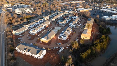
Don Evans Photography delivers high-resolution construction timelapse monitoring and repeatable visual documentation for Piedmont Triad commercial and industrial developments.
Request Site Feasibility
Send project details for a quick 15-minute consult and custom documentation proposal.
Executive Stakeholder Reporting
Keep investors and off-site developers fully updated without them ever stepping foot in the mud. We provide centralized aerial data that makes audits easier and keeps your teams on deadline.
Pre-Emptive Defect Mitigation
Identify underlying structural, grading, or topographical defects from 400 feet in the air before they become expensive, schedule-killing ground-level issues.
Zero-Friction Airspace Compliance
Stop worrying about FAA authorizations or $11,000 federal fines. We embed airspace checks directly into our planning phase and store approvals automatically for your legal compliance.
The 37% Shift in Construction
With over a third of US construction sites now utilizing aerial data, developers are realizing that building an in-house fleet is a costly distraction. We provide the intelligence without the overhead.
In-House Drone Software
- Expensive monthly fleet management subscriptions.
- HR burden of hiring and retaining licensed Part 107 pilots.
- Internal liability and insurance risks for site incidents.
- Manual FAA airspace authorization bottlenecks.
- Hardware depreciation and costly equipment upgrades.
Turnkey Reality Capture
- Zero subscriptions. Pay only for the data you need.
- Zero HR friction. We arrive, execute, and deliver.
- Total protection. Covered by our $1M+ commercial liability.
- Automated compliance. We handle all FAA LAANC authorizations.
- Top-tier tech. Access 4K/6K optics without buying the hardware.
Reality Data Capture
- Repeatable Accuracy: Scheduled missions that capture site evolution with exact precision.
- Standardize Workflows: Consistent safety and inspection protocols across all your active builds.
- Defensible Documentation: Time-stamped proof to mitigate risks and resolve schedule disputes.
- BIM Support Visuals: High-resolution visual assets to support 3D modeling and engineering.
Integrated Monitoring
- Passive Time-lapse: 4K long-term tracking for the full build lifecycle.
- Centralized Aerial Data: Ensure all stakeholders have real-time visibility during surveys.
- Reduced Site Friction: Fewer delays and miscommunications between site supers and executives.
- Actionable Intelligence: Instant visual confirmation of task completion and staging.
Mission Certainty
- FAA Part 107 Certified: Professional aviation standards applied to every flight.
- Disciplined Workflows: Strict airspace coordination and safety protocols.
- Full Liability Coverage: Enterprise-grade $1M+ insurance for industrial zones.
- Direct Access: One-on-one collaboration with the pilot for custom reporting.
Site Intelligence Tiers
Standard Progress Suite
(Drone Only Coverage)| Aerial Mission Bi-Weekly Visits | $500 /mo |
| Deliverables High-Res Stills | Included |
| Context 4K Perimeter Video | Included |
Integrated Site Intelligence
(Drone + Daily 4K Timelapse)| Workflow Single-Zone Capture* | $850 /mo |
| Hardware 4K Weatherproof Unit | Included |
| Data Sync Daily WiFi Uploads* | Included |
*Requires on-site WiFi access for remote sync.
Reserve Site BundleEnterprise Reality Capture
(Multi-Site & BIM Support)- Reality Assets for BIM Support
- Full Perimeter Timelapse Arrays
- Multi-Site Regional Contracts
What is "Passive Monitoring?"
A weather-sealed camera system deployed for build tracking and stakeholder transparency.
How do you handle site safety?
I am a Part 107 Certified pilot. Drone monitoring eliminates manual high-altitude risk.
Can we request on-demand video?
Yes. Ground-level cinematic units complement aerial progress shots for project milestones.
What region do you cover?
We provide professional reality capture throughout Greensboro, Winston-Salem, High Point, and the Triad.
Detailed Project Consultation
Read our guide on FAA Compliance and Drone Liability